75
Years of Air Traffic Control at Ronaldsway 1937 - 2012
The Isle
of Man Airport
Ronaldsway - The Isle of Man
Airport
A brief illustrated
history of the airport and its Air Traffic Control
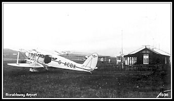
Ronaldsway has
served as the airport for the Isle of Man since 1934 when a license was
granted for public transport operations from a large field on Ronaldsway
farm, in the south of the island. A rival northern airport was also established
at Close Lake to the west of Ramsey.
Named 'Hall Caine Airport'
after the famous Manx novelist, it operated from 1933 until 1937. During
WW2 Ronaldsway was
taken over first by
the RAF and then the Royal Navy but continued operating (with both military
and civil ATC) as the island's airport.
RAF Airfields were constructed
at Jurby and Andreas in the north of the island.
 Ronaldsway Airport
- 1938
Ronaldsway Airport
- 1938
|
 Ronaldsway Airport
- Present Day
Ronaldsway Airport
- Present Day
|
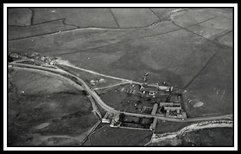
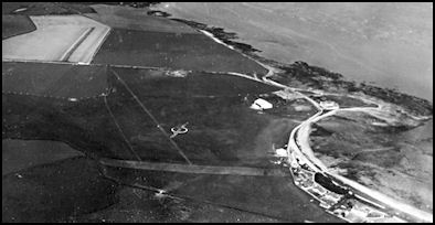 Aerial View of Ronaldsway
Airport in 1938
Aerial View of Ronaldsway
Airport in 1938
|
During World War Two
the UK Air Ministry requisitioned Ronaldsway and an RAF unit specializing
in gunnery training arrived in July 1940, operating from the existing grass
airfield and staying until early 1943 when a huge reconstruction and expansion
of the airfield with four tarmac runways commenced for the Royal Navy,
being completed in Spring 1944.
 RAF Ronaldsway 1942
|
 HMS Urley, Ronaldsway
1945
HMS Urley, Ronaldsway
1945
|
Civil passenger air
services from Ronaldsway continued (with some small interruptions), under
civil ATC control throughout the war
with scheduled services
using a small fleet of DH Dragon Rapides flying to Liverpool and Belfast.
Jurby and Andreas
Airfields
During WW2 Jurby and
Andreas airfields were built for the RAF in the north of the island, Jurby
was mainly used for bomber and gunnery training, Andreas being mainly a
fighter and Search and Rescue airfield. Each had their own control towers
and military ATC. A Sector Operations room was constructed at Ramsey for
fighter control over the north Irish Sea fed by information from the Chain
Home radar sites at Scarlett, Dalby and Bride and the Chain Home Low station
at Cregneash.
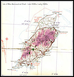 Aeronautical Chart
1930s - 40s
Aeronautical Chart
1930s - 40s
|
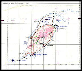 Aeronautical Chart
1950s
Aeronautical Chart
1950s
|
Post WW2 Jurby continued
in limited RAF use for a while and was then used as a diversion airfield
for Ronaldsway when weather in the south made operations impossible. A
civil Air Traffic Control team would be dispatched from Ronaldsway together
with fire vehicles and ATC would operate from the former RAF control tower.
The main runway at Jurby was lengthened across the Sandygate road to be
able to accept Viscount turboprop airliners. Regular air shows were held
here until 2004.
Today, the only
public airport for the Isle of Man is at Ronaldsway, although a limited
amount of private flying uses the airfield at Andreas
in the north of the
island, mainly gliding and microlights with few private grass airstrips
in use.
Aviation activity at
Jurby has to all intents and purposes ceased and the airfield is now mainly
used for motor cycle racing activities.
Ronaldsway airport has
been rebuilt over the years with runways widened and extended, plus new
taxiways and buildings.
Nowadays just two runways
are used, giving four landing or take-off directions, the others have become
taxiways.
Air Traffic Control
facilities have been regularly updated and at present we are in process
of testing and evaluating a new combined Primary and Secondary Mode 'S'
'Multilateration' radar system before it commences operational use.
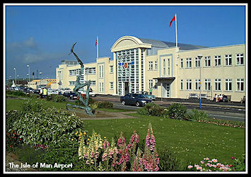
The
Isle of Man Airport Official Website
Ronaldsway Air Traffic
Control
On July 8th 2012, Ronaldsway
Air Traffic Control achieved 75 continuous years of service,
here's a quick potted
history. For more details please see the ATC History pages.
|
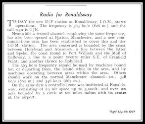
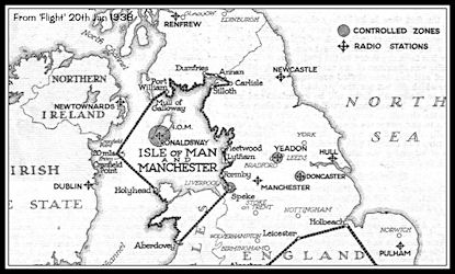
The start of ATC
operations at Ronaldsway
was announced in
this 'Flight' column from July 1937
Air Traffic Control
commenced operations at Ronaldsway on July 8th 1937 when a medium
frequency Direction Finding station was established together with a
'Controlled Zone' of
10 miles around the airfield up to
3000 ft and a 'Communications
Area' covering the northern part
of the Irish Sea.
|
|
The Controlled Zone
The Controlled Zone
only came into operation during periods of poor visibility or low cloud,
when all aircraft required permission form ATC to enter the zone or depart
from the airfield. Only one aircraft was allowed into the zone at a time,
others being held outside or on the ground. In good weather conditions
a pilot could fly overhead the airfield and observe the 'Signals Square'
a defined area close to control where large ground signals were displayed
to indicate the landing direction and any non-standard procedures in use.
Pilots would usually fly a left hand circuit to the runway, giving way
to any other aircraft ahead or below them and not land until they could
see that the runway was clear or received a light signal from control.
Radio communications
between aircraft and ATC were generally by Morse Code via specialist radio
operators in the aircraft and on the ground. The Air Traffic Controllers
passed instructions written on paper message forms to the operators for
transmission and received the replies back in the same format. An abbreviated
code system know as the 'Q' code was used to keep messages shorter, most
routine messages having a three letter code beginning with 'Q' assigned
|
|
The Communications
Area
The Communications Area
was jointly administered by Ronaldsway and Manchester (Barton first and
then Ringway) and provided a service to participating radio equipped aircraft.
Information on conflicting flights would be passed to pilots with suggestions
as to heights or tracks to fly. The service was not compulsory and information
could only be passed on known flights, it was up to pilots as to whether
they acted on advice given.
This was the first such
communications area not serving the London airports and shows the importance
of the Irish Sea air Routes.
|
|
|
An Air Traffic Control
service has been provided on a continuous basis since then, including the
wartime years serving the civil air link between Liverpool, the Isle of
Man and Belfast when most other civil control services were closed down,
making Ronaldsway possibly the longest continuous serving ATC unit in the
British Isles.
VHF radio and D/F
Post WW2 VHF radio came
into common use, enabling controllers and pilots to talk directly to each
other without the intermediary of a Radio Operator and the Medium Frequency
radio services were phased out. Cathode Ray VHF radio Direction Finders
came into use, giving the controller an instant bearing on any aircraft
transmission
|
|
|
|
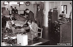 The ATC Control Room
in 1948
The ATC Control Room
in 1948
|
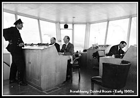
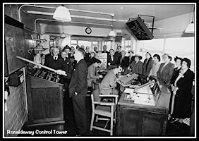 The ATC Control Room
in the 1950s
The ATC Control Room
in the 1950s
|
|
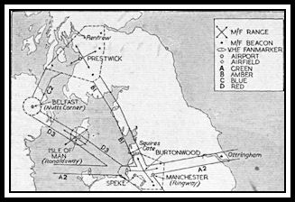
Airways and Radar
In the early 1950s a
major change was made to UK Air Traffic Control procedures with the introduction
of the 'Airways' system with corridors of controlled airspace linking the
major hubs where Control Zones and Control Areas surrounded the airports.
Preston Centre controlled the airway 'Red Three' that went overhead the
Isle of Man from Wallasey in the Wirral to Belfast. A Radio Range
beacon was established at Cregneash to facilitate navigation over the Irish
Sea. Control was initially by 'Procedural' methods using vertical separation
or time intervals between aircraft flying at the same or crossing levels
but radar started to be used experimentally in the London area during the
1950s although not becoming widespread across the UK until the mid 1960s.
From Preston local Area
Control services moved initially to Manchester and subsequently to Scottish
Control at Prestwick.
|
At the end of
the 1950s a new Visual Control Room was constructed on top of the former
Royal Navy watch office
and all ATC functions
moved there from the old control room on the second floor.
 The New Visual Control
Room
The New Visual Control
Room
|
 Inside the new Visual
Control Room
Inside the new Visual
Control Room
|
|
New Instrument Approach
Aids and Radar
Ronaldsway was one of
the early post war civil airfields to be equipped with Standard Beam Approach
(SBA), a pilot interpreted blind approach aid which would position the
aircraft onto a final approach track to the runway and provide rudimentary
glidepath (descent) information. This was subsequently supplemented and
then replaced by an Instrument Landing System (ILS) that gave accurate
lateral (Localizer) and vertical (Glideslope) information presented on
a cockpit instrument with descent in cloud possible down to a safe level
of 200 ft. This equipment has been updated several times and is now available
for approaches to both ends of the main runway. Other landing aids provided
were a Medium Frequency Non Directional Beacon (NDB) and a VHF Omni Directional
Radio Range (VOR). In 1966 a state of the art Plessey AR-1 surveillance
radar was installed, the same type that was in use at London Heathrow airport.
|
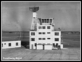 The control tower
with new radar scanner installed
The control tower
with new radar scanner installed
|
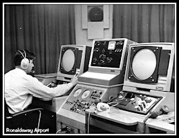 Testing the new radar
equipment
Testing the new radar
equipment
|
Air Traffic Control
currently occupies its fourth building, having moved from the 1944 vintage
Royal Navy tower in 2010.
Ronaldsway
ATC Homes over the Years
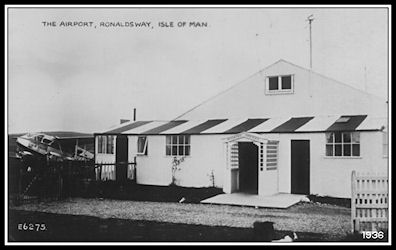
 1930s A wooden
building on the grass airfield
1930s A wooden
building on the grass airfield
|
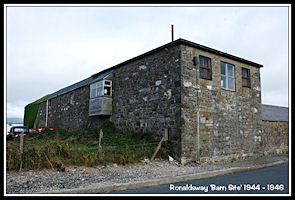 1944 - 1946
Ronaldsway Farm 'Barn Site'
1944 - 1946
Ronaldsway Farm 'Barn Site'
|
|
|
|
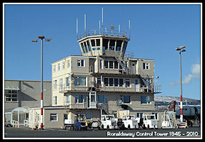 1946 - 2010
Former Royal Navy Control Tower
1946 - 2010
Former Royal Navy Control Tower
|
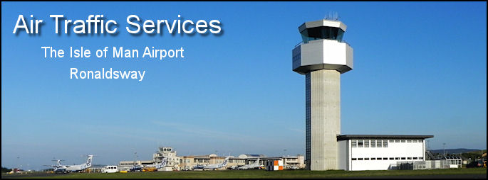
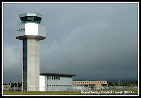 2010 - Purpose
build modern Control Tower
2010 - Purpose
build modern Control Tower
|
Isle of
Man ATC - a more detailed history
Photographs of aircraft
at Ronaldsway since 1990 are in the
Island
Images Aircraft Pages
Island
Images Homepage
|