ATC Operations at Ronaldsway
since my retirement in September 2014
An attempt to record
some of the changes to ATC operations from then up to the present day.
ATC is a constantly evolving operation with new equipment and procedures
being introduced on a regular basis. As I am no longer working there,
I am using various sources to keep up with the changes.
For a detailed explanation
of day to day ATC at Ronaldsway see ATC 2014
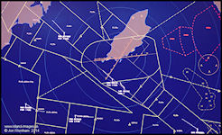
Airspace Revision - November
2014
With effect from the
13th November 2014 all class 'F' Advisory Routes within UK airspace were
abolished, either completely or replaced with another category of Controlled
Airspace. Around the Isle of Man route W2D to Pole Hill (for Blackpool
& Leeds), W911D to Dean Cross (for Newcastle) and W928D to BLACA (for
Prestwick & Glasgow) were abolished and became Class G airspace.
Aircraft formerly using these routes now leave the air route structure
as soon as they cross the Isle of Man Control Zone boundary, unless they
choose a longer less direct route. Ronaldsway Radar can provide a
service until around 40 miles away and then hopefully hand the aircraft
off to another agency. In many cases Scottish Control are happy to
provide a service to these aircraft, depending on controller workload.
Route W911D from IOM
to BOYNE (for Dublin) changed to a class 'E' airway and was renamed Y911
with a base level of Flight Level 75, the airspace is also a Transponder
Mandatory Zone (TMZ) for VFR aircraft wishing to operate within its confines.
Aircraft operating under the Visual Flight Rules can cross the airspace
without a clearance so long as they have an operational Mode-S radar transponder,
making them visible to ATC.
The base level of FL75
can cause some additional workload to Ronaldsway controllers, particularly
when runway 08 is in use as the Manual of Air Traffic Services states that
controllers should keep aircraft with Controlled Airspace if at all possible,
but with a short distance to touchdown from the Control Zone boundary it
is almost inevitable that pilots will request to descend below the airway
to avoid additional routing and wasting fuel, the ATC service being provided
to them might then change three times within around 20 miles.
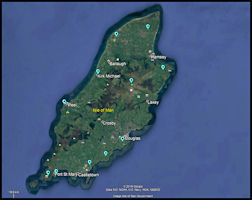
 Revised airspace
around the Isle of Man from 13th November 2014
Revised airspace
around the Isle of Man from 13th November 2014
|
Changes to Ronaldsway's ATC
Radio Frequencies and remote Approach Radar Radio Station - December 2014
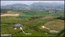
A project that dates
back to the 1990s to improve Ronaldsway's VHF radio coverage at lower levels
over the north of the island became operational towards the end of 2014.
Originally planned and tested with an additional transmitter/receiver station
on 120.850 at Jurby, revised plans have re-located the main Approach/Radar
radio station to Snaefell summit from the airfield at Ronaldsway. Due to
the new location and mountain top elevation, this required alterations
to the main operating frequencies for Ronaldsway to prevent interference
to other aeronautical radio stations. On the 22nd September 2014 'Radar
2' frequency 118.2 MHz was permanently withdrawn from service to allow
engineering work to commence for the main frequency changes. With effect
from the 11th December 2014 the new operating frequencies are:
Ronaldsway Approach/Radar
- 135.9 MHz
Main transmitter/receiver
on Snaefell Summit, with standby at Ronaldsway
Ronaldsway Tower
- 119.0 MHz
Transmitters & receivers
remaining at Ronaldsway
Other (when instructed
by ATC) frequencies are 120.850 and 125.3 and can be used for a second
radar position or Ground Movement Control when traffic requires. The old
Tower frequency of 118.9 was replaced by 119.0 and is no longer available
at Ronaldsway. This change to the primary Approach and Tower frequencies
was the first since they were introduced into service on the 16th January
1964.
Replacement of ATC Surveillance
systems at Ronaldsway - 2011 onwards.
A requirement that was
identified around 2010 was to replace the 15 year old Watchman PSR &
Cossor SSR radar systems. The Watchman would have required extensive
refurbishment to continue in operation and the Cossor Mode A/C SSR needed
to be replaced by the start of 2012 to comply with requirements to operate
only Mode-S systems. The replacement systems chosen were a Selex
ATCR-33S Primary Surveillance Radar to be installed at Ronaldsway with
a Wide Area Multilateration Mode-S SSR system operating from multiple sites
around the island. Part of the project included a ground surveillance
system showing aircraft and vehicle positions on the airfield, utilising
additional local receivers. A more conventional airport located SSR
Mode S system was also considered, but the WAM system promised to greatly
enhance surveillance coverage at lower levels to the north, where the hills
created a 'radar shadow' for airport based systems. Another benefit
was to be the airport ground surveillance of aircraft and vehicles, particularly
useful at night and in poor visibility when it can be difficult or impossible
to see the airfield from the control tower.
Wide Area Multilateration
(WAM)
The Wide Area Multilateration
(WAM) system works utilises a very different technique to older conventional
SSR systems. Instead of having a rotating aerial interrogating the
aircraft transponders and receiving replies, it has multiple sites located
around the island. There are four active transponder interrogators
operating on 1030 MHz and eleven receivers on 1090 MHz, plus four 'Squitter
Generator' transmitters on 1090 MHz that are used for system self checking
to ensure integrity. The interrogators and SGUs are co-located at
receiver sites. The WAM system computes aircraft positions in three
dimensions (only two are used in ATC displays) by registering the Time
of Arrival (TOA) of aircraft transponder replies at some or all of the
multiple receiver sites. To guarantee timing accuracy all of the
sites have independent GPS receivers. The TOAs are sent to the processor
in the control tower where they are also integrated with the Primary Radar
returns from the ATCR-33S radar at Ronaldsway before being displayed on
the controllers Situation Displays, a newer term for what used to be known
as radar displays. There is also an option to integrate aircraft
generated ADS-B position reports, a system that is likely to see much wider
use in ATC over the coming years. A further eight receivers are located
around the airport to provide coverage of aircraft and vehicle movements
on the airfield and a selection of vehicles that are regularly used on
the manoeuvring area are fitted with transponders to show their position
on a display in the Visual Control Room.
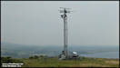
Remote Aerial Locations
 Wide Area Multilateration
Sites
Wide Area Multilateration
Sites
|
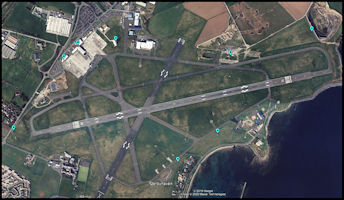 Airport Ground Surveillance
Sites
Airport Ground Surveillance
Sites
|
Elements of
the Ronaldsway Surveillance System
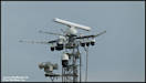
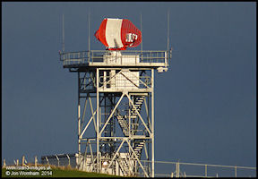 Selex ATCR-33S Radar
at Ronaldsway
Selex ATCR-33S Radar
at Ronaldsway
|
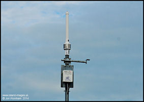 Selex Wide Area Multilateration
Aerial
Selex Wide Area Multilateration
Aerial
|
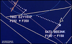
The new radar system
is completely processed with no primary radar 'blips' displayed on the
screen as with the older system. Instead, different symbols are used
to show the source and type of information displayed. The primary and secondary
radar is combined electronically and aircraft tracks are then displayed
to the controller.
A Primary Radar only
contact is show as a vertical cross +
A Secondary Radar (SSR)
only contact is shown as a diagonal cross x
A combined contact (PSR
& SSR) is shown as a star *
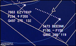
Additional information
is provided to the controller based on information being downlinked from
the aircraft Mode-S transponder, depending on the type of transponder fitted
into the aircraft. The most basic information displayed shows the
aircraft radio callsign, either as a Flight Number for airline flights,
Aircraft Registration, or Military Callsign. This information can
be stored in the transponder in the case of aircraft registration, or has
to be entered by the crew before each flight in other cases. The
aircraft 'height' is downlinked and displayed either as a 'Flight Level'
or an Altitude if the aircraft is below 3,000ft.
More advanced transponders
also downlink 'Enhanced Parameters'. This can include, selected level
on the autopilot, aircraft indicated airspeed, actual aircraft heading
and the barometric pressure set on the altimeter. These can be displayed
on the controllers display as required. From the Selex Primary Radar, digitized
weather returns can be overlaid on the display to plan for weather avoiding
requirements by pilots.
Display Screenshots
 Selex data on the
Situation Display
Selex data on the
Situation Display
|
 Mode-S two line Data
Block
Mode-S two line Data
Block
|
 Mode-S three line
Data Block
Mode-S three line
Data Block
|
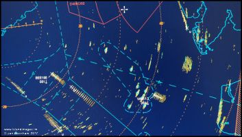
 Primary radar returns
from rain showers around the Isle of Man
Primary radar returns
from rain showers around the Isle of Man
|
Airport Ground Surveillance
 Airport Surveillance
Test Display
Airport Surveillance
Test Display
|
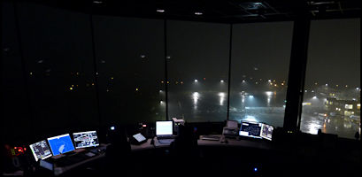 Ronaldsway Visual
Control Room with poor visibility at night
Ronaldsway Visual
Control Room with poor visibility at night
|
System installation
and introduction into service 2011 - 2017
The equipment was installed
during 2011 and data was being displayed in the control tower by January
2012 but due to various unforeseen technical issues, the project
had an extended development period to try and bring it up to an acceptable
performance level before it could be used by ATC. As a result of
this the Watchman radar had to be modified (in common with all existing
ATC 10 Cm radar systems) to prevent interference from 4G mobile phone transmissions
that were planned to operate at frequencies adjacent to those of ATC radars.
The Cossor Secondary Radar System suffered a major fault and was temporarily
withdrawn until a new aerial could be installed and the system returned
to service. Temporary permissions had to be obtained from the UK
CAA to continue operating the Mode A/C SSR system.
The new system went
'live' on the 3rd September 2017, operating in a combined Primary Surveillance
& Multilateration Secondary radar only mode. The Ground Surveillance
part of the system has so far (2023) not come into service and it seems
to have been abandoned. There are also limits to services outside
controlled airspace compared to the old Watchman/SSR system, with warnings
and advice on unknown traffic being limited to transponding aircraft only.
Radar Interference from Wind
Farms
It is an unfortunate
fact that the growing number of both onshore and offshore wind farms are
causing problems to ATC radar surveillance capabilities. Most ATC
radars cancel out unwanted 'static' returns by using filters that detect
the difference between stationary and moving targets. Wind turbines,
by their very nature are presented to the radar processor as moving targets
and it is therefore are difficult to remove them as clutter on the display.
The older Watchman radar at Ronaldsway suffered from this from time to
time, even though the nearest wind farms at the time were technically over
the 'radar horizon'.
 'Anaprop' Clutter
on the Watchman Radar Display
'Anaprop' Clutter
on the Watchman Radar Display
|
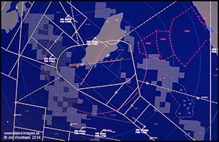
Walney Transponder
Mandatory Zone (TMZ)
The problem with newer
fully processed radar systems is that when sufficient levels of data processing
are introduced to remove the unwanted clutter from wind farms on the display,
the actual aircraft returns can also be removed. Secondary Surveillance
Radar returns should be unaffected by the wind turbines and a Transponder
Mandatory Zone (TMZ) has been established over the wind farm for the benefit
of Warton airfield, located near to Blackpool and operated by BAe for the
production and flight testing of Typhoon and Hawk aircraft. The TMZ
only operates during Warton's notified hours of opening from Monday to
Friday and any aircraft that wishes to transit through the airspace must
either be fitted with a serviceable Mode-S transponder or contact Warton
for a clearance to transit. At present, Ronaldsway is having to restrict
radar services offered outside controlled airspace.
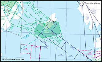
 Restricted Airspace
in the northern Irish Sea around the Isle of Man
including the Walney
Transponder Mandatory Zone (TMZ)
Restricted Airspace
in the northern Irish Sea around the Isle of Man
including the Walney
Transponder Mandatory Zone (TMZ)
|
Rationalization of the UK Ground
Navigation Aid Infrastructure - 2014 onwards.
With a major change
under way to 'Performance Based Navigation' (PBN) using GPS (backed up
and checked by other systems, e.g. DME beacons) as the main navigation
source for aircraft there is a program by NATS En-Route Limited to reduce
the number of ground based radio aids. Around the northern Irish Sea area
the VOR at Dean Cross (DCS) was withdrawn from service in December 2014,
leaving the DME in operation and plans indicated that the VOR beacons at
Glasgow (GOW) and Turnberry (TRN) would be removed in 2016 and Manchester
(MCT) in 2017. In fact, all of these beacons remained in service as of
November 2017. As of early 2019, the Glasgow VOR has been decommissioned
as an en-route aid, but remains operation with reduced protected range
as an approach aid for Glasgow Airport. Two new DME only beacons
established at Dundonald (DUD - just north of Prestwick Airport) and Green
Lowther (GLO - in the Scottish Borders close to the village of Wanlockhead).
The New Galloway Non
Directional Beacon 'NGY' was scheduled to be withdrawn in 2016, remained
in service as of November 2017, but seems to have gone by January 2020.
The VOR/DME beacons at Isle of Man (IOM), Belfast (BEL) and Wallesey (WAL)
are scheduled to be replaced with new equipment. The Isle of Man
beacon was re-furbished during the summer and autumn of 2017 and was due
back in service on the 15th December. Where the VOR beacons have
been removed, the Distance Measuring Equipment (DME) element usually remains,
as this is an important component for area navigation systems in aircraft.
They can be used to determine an aircraft's exact position automatically
by using the DME ranges from two or more beacons and this can be used to
check the integrity of other navigation systems.
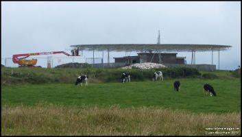 The 'IOM' VOR/DME
beacon undergoing work in July 2017
The 'IOM' VOR/DME
beacon undergoing work in July 2017
|
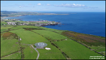 Aerial view of the
'IOM' VOR/DME in 2018
Aerial view of the
'IOM' VOR/DME in 2018
|
 A near vertical view
of the 'IOM' VOR/DME
A near vertical view
of the 'IOM' VOR/DME
|
Changes to agreed levels for
Ronaldsway traffic on Airway L10 to the south east.
'Agreed Levels' are
long term arrangements between different air traffic control agencies to
reduce co-ordination requirements, every flight being climbed or descended
to the agreed level, usually by a certain geographical location.
The agreed levels with Scottish Control for traffic operating on airway
L10 to the south east of the Isle of Man had fo a long time been set too
low for many modern high performance aircraft.
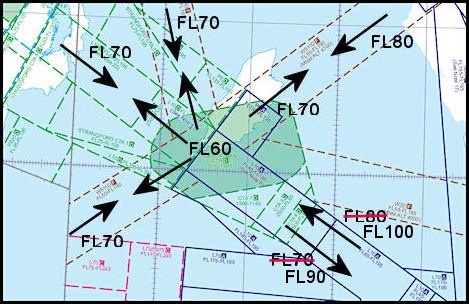 The revised 'Agreed
Levels' with Scottish Control on Airway L10
The revised 'Agreed
Levels' with Scottish Control on Airway L10
|
The previous agreed
outbound level for traffic heading south east towards Liverpool was Flight
Level 70 (7,000 ft) which often caused a problem with higher performance
aircraft such as the FlyBe Dash8s and EasyJet Airbus's reaching it rapidly
after departure from Ronaldsway, resulting in a lot of extra telephone
co-ordination between Ronaldsway and Scottish Isle of Man Sector.
Also inbound aircraft were being forced to descend earlier than they would
like to achieve the agreed inbound level of FL80 (8,000 ft) abeam point
KELLY, 15 miles to the south east of the airport and about 20 miles from
touchdown if runway 26 was in use but 40 miles from touchdown if runway
08 was in use. Raising the inbound agreed level to FL100 (10,000
ft) allowed outbound aircraft to be climbed up to FL90 (9,000 ft) without
any co-ordination between Ronaldsway and Scottish Isle of Man Sector.
Airspace changes to the
south east of the Isle of Man
Introduction of RNAV-1 routes
- 9th November 2017
In 2016, NATS
notified that there was going to be a big change in the way airspace below
FL245 (24,500 ft) was to be designated. The existing 'Airways' structure
dated from the early 1950s (see ATC
1950s for more information) and in recent years the designations had
been in contravention of international agreements. With the move
to more Area Navigation (RNAV) systems and the removal of many of the old
radio beacons, multiple routes were being designated within the same volume
of airspace. To correct the anomalies, a rolling program of re-designation
of the old Airways to Control Areas was started and the airspace to the
south and east of the Isle of Man was changed in early November.
Airways L10 and L70 (amongst others not affecting Ronaldsway) have had
their airspace status changed from Class A to Class C and been re-designated
as the 'Holyhead Control Area'. The rather strange and short Class
E Airway 'Y911' to the southwest of the Isle of Man also becomes part of
the Holyhead Control Area, but retains its Class E status.
Within this airspace
there are various routes designated, including one called L10 which in
fact just follows the old airway centreline. There are also new routes
to the north and south of L10, M146 which is for northwest bound traffic
and Q39 for southeast bound traffic. There are yet more, but these three
are the only ones affecting Ronaldsway traffic. The reason
for such a plethora of routes is that the newer ones require aircraft navigation
performance to RNAV-1 (with a higher accuracy required) whereas there are
still many aircraft around that can only manage RNAV-5, which has a lower
accuracy requirement, ATC radar being used to ensure separation between
the two classes. Eventually it will be a requirement for all aircraft
using the Controlled Airspace System to carry RNAV-1 when, presumably,
the structure can be simplified.
 Northern Irish Sea
Airspace classes from 9/11/17
Northern Irish Sea
Airspace classes from 9/11/17
|
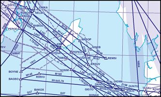 Lower Airspace ATS
Routes from 9/11/17
Lower Airspace ATS
Routes from 9/11/17
|
Normal practice
is to link these routes to an airport via Standard Terminal Arrival Routes
(STARs) and Standard Instrument Departures (SIDs) which are pre-programmed
into most modern aircraft Flight Management Systems (FMS).
The pilot then just has to select the appropriate SID from his departure
airfield, then the relevant routes until connecting with the STAR at his
destination which in turn connects to the Instrument Approach Procedure
for the runway in use. At present Ronaldsway does not have STARs
and SIDs, which can cause some confusion to visiting aircrew as to how
they connect with the en-route structure.
Manual of Air Traffic Services
Part 1
7th Edition published
- Effective date 28th December 2017
The MATS Part 1 is effectively
the 'bible' of Air Traffic Control in the UK (and Isle of Man) and the
First Edition was published in 1974, not long after I had started my career
in ATC the previous year. Before then the publication had been known
as the Manual of Air Traffic Control. To quote from sections of the
foreword of the latest version:
'The Manual of Air Traffic
Services contains procedures, instructions and information, which are intended
to form the basis of ATS within the UK'.
Part 1 of the Manual
contains instructions that apply to all UK ATSUs and is published by the
UK CAA. Part 2 contains instructions that apply to a particular ATSU
and is produced locally but are approved by the CAA. A copy of the
latest edition of Part 1 can be downloaded
here.
New editions are published
when there are major changes to ATC procedures and Edition 7 is mainly
concerned with changes associated with the move to a Standardized European
Rules of The Air (SERA).
Communications Frequency Changes
11th October 2018
8.33 KHz separated Channels
All ATC frequencies
within Europe have been gradually changing from frequencies separated by
25 Khz to a closer 8.33 KHz separation, in order to provide a much greater
number of available frequencies. Area Control was the first to implement
these on a rolling program starting some years ago, with UK airfields changing
during 2018. In some cases new frequencies have been allocated, but
in others the only change is to the designation of the frequencies to indicate
that they are 8.33 KHz channels. The new designators, while looking
like actual frequencies, are in fact just 'Channel Designators' and are
close to, but not the actual frequencies used. Some Area Control
frequencies, where multiple ground stations are using the same frequency
to produce the required coverage, have remained at 25 KHz separation for
the time being.
In Ronaldsway's case
there are no actual changes to the frequencies, just the channel designations:
Ronaldsway Approach/Radar
- 135.905 (Actual carrier frequency still 135.9 MHz)
Main transmitter/receiver
on Snaefell Summit, with standby at Ronaldsway
Ronaldsway Approach/Radar
(when instructed by ATC) 120.855 (Actual carrier frequency
still 120.85 MHz)
Transmitter/receiver
at Ronaldsway
Ronaldsway Approach/Radar
(when instructed by ATC) 125.305 (Actual carrier
frequency still 125.3 MHz)
Transmitter/receiver
at Ronaldsway
Ronaldsway Tower
- 119.005 MHz (Actual carrier frequency still 119.0 MHz)
Transmitters & receiver
at Ronaldsway
Ronaldsway ATIS
123.880 (Actual
carrier frequency still 123.875 MHz)
Transmitter at Ronaldsway
Airspace Revision from 23rd
May 2019
With effect from this
date the upper limits of the Isle of Man Control Zone and Control Areas
will be raised from Flight Level 65 to Flight Level 105. The main
benefit to Ronaldsway traffic is that it will enable airways aircraft inbound
from the south east for runway 26 to be turned towards the ILS intercept
point earlier, thereby reducing track miles flown and fuel burn.
There have also been some minor changes to the airspace boundaries.
Airport reduced operating hours
2020 - 2023
The Covid 19 pandemic
affected operations at Ronaldsway greatly, with the airport operating on
greatly reduced hours from March 2020 and Loganair operating the only scheduled
service, subsidised by the IOM Government. The reduced hours of operation
continued after personal movement restrictions on the island were lifted,
enabling me to take a series of aerial photographs around the airport during
April and May 2020 while it was closed.
Ronaldsway
Airport Aerial Pictures
For some reason (which
I won't speculate on here), the airport has struggled to recruit or train
Air Traffic Controllers to replace those who have either retired or left
for various reasons, resulting in limitations as to the services available
at time and also affecting airport operating hours. At the time of
writing this update (September 2023) the airport is notified as having
to close between 08:30 and 09:05 (local time) and again between 11:00 and
11:35. This is to allow legally required fatigue breaks for the much
reduced roster of trained controllers. Radar services are also liable
to be unavailable at times due to staff shortages, with a single controller
carrying out combine Tower and Approach duties. However it still
seems to be possible to extend the evening opening time to accommodate
late running airline schedules. The published airport closing time
is 20:45 (local time), but extensions up to 23:00 local time seem to be
quite common. After this time the controllers 'run out of hours'
and the airport has to close. Late evening extensions also have the
potential to affect staffing levels for the following morning, the possibility
being that radar services might not be available until a controller who
stayed late on the previous evening had completed the minimum number of
hours required between shifts. Hopefully the situation will improve,
but there is a world-wide shortage of trained controllers and it can take
several years to train a new entrant controller to be fully validated on
all positions.
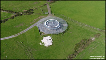
VOR/DME Approach
not availaible from August 2023
A couple of NOTAMs about
this. One is that bearings from the 'IOM' beacon between 080 and
120 degrees might fluctuate and presumambly as a result of this, the VOR/DME
approach to runway 08 at Ronaldsway is withdrawn. The current NOTAMs (September
2023) for the fluctuations continues until 23rd October although the one
for the approach being withdrawn is only until 24th September. I'm
guessing the the potential interferrance is being caused by this radar
installation, although I would have though that the company that intstalled
it would have enquired with NATS as to the suitability of the site!
'Cregneash Radar'
|